Starting Point: I-75 exit 49. Follow U.S. Highway 25 north to Livingston. Turn right onto Highway 490 and travel several miles to Kentucky Scenic Byway 89 on the left.
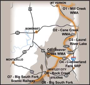
O1 - Mill Creek Wildlife Management Area (WMA)

Follow 89 Scenic Byway northeast, which splits the WMA after approximately 15 miles. Several gravel roads are open to travel from 89 to interior portions of the WMA. Gas, lodging, and dining opportunities in nearby McKee.

The Mill Creek WMA in Jackson County is part of the Daniel Boone National Forest, managed cooperatively with the Kentucky Department of Fish and Wildlife Resources. Within the WMA, 89 grassy openings (over 150 acres) are routinely mowed or planted to provide suitable habitat and forage for wildlife. Rolling hills covered in hardwood forest surround these openings, and the creeks below are shaded by dense rhododendron. The Sheltowee Trace NRT runs through a portion of the WMA on the western side.

Wildlife Viewing Opportunities
: Wild turkeys, white-tailed deer, grouse and quail are commonly seen along this trail. The diversity of habitats, from openings to dense forest, provides suitable breeding territory for many of Kentucky’s songbirds. Various mammals, reptiles and amphibians can be found here and the wildflowers in the spring and summer are breathtaking. In April, Virginia bluebells blanket the riverside slopes of the Middle Fork of Rockcastle River. The wood poppy with their rich yellow petals of wood poppies can also be found.
O2 – Cane Creek Wildlife Management Area (WMA)

North of Laurel River Lake along Highway 192. *Lodging, dining and gas opportunities in nearby London.

The Daniel Boone National Forest, in cooperation with the Kentucky Department of Fish and Wildlife Resources, manages the Cane Creek WMA. Habitat is managed specifically for game species, but management also benefits many non-game wildlife species. More than 60 acres of wildlife openings are maintained in this area, surrounded by dense woodlands on rugged terrain. Sandstone cliffs separate the ridge top elevations from the creek bottoms below. For a closer look inside the Cane Creek WMA, hike the Sheltowee Trace NRT that transects the area’s interior.

Wildlife Viewing Opportunities:
The area has a growing population of wild turkeys and white-tailed deer. Grouse and quail may also be observed. Travel to the west side of the WMA along the Rockcastle River at Bee Rock to hear prothonotary warblers and other songbirds during the breeding season. Watch for spotted sandpipers, herons, wood ducks and woodpeckers along the riverside. This riparian area provides excellent habitat for various species of salamanders. The diversity of habitat within the WMA also provides for an array of spring wildflowers too numerous to mention.
O3 – Laurel River Lake

From London: Take I-75 exit 38 and travel west on Highway 192. To Holly Bay Marina, travel 192 west to 3497, then left onto 1193. *Lodging, dining and gas opportunities in nearby London.

Laurel River Lake is part of the Daniel Boone National Forest, featuring 5,600 acres of water and nearly 200 miles of shoreline. Laurel River Lake provides excellent sport fishing for walleye, trout and bass. Developed campgrounds and hiking trails are available at various locations around the lake.

Wildlife Viewing Opportunities:
The Lake is home to nesting bald eagles. The number of bald eagles on the lake increases during the winter months. A Canada Goose Management Area on the lake provides opportunities for viewing Canada geese and white-tailed deer foraging in the open fields. During the winter, look for swimming birds such as common loons, black ducks, hooded mergansers and double-crested cormorants. The forested habitat surrounding Laurel River Lake provides listeners with the musical sounds of Kentucky’s breeding songbirds during the spring and summer. In the quiet bays, watch for pied-billed grebes, kingfishers and rough-winged swallows. The great blue heron can often be observed wading along the lakeshores and look for ospreys flying over during migration. Deer are plentiful along with squirrel and raccoon.

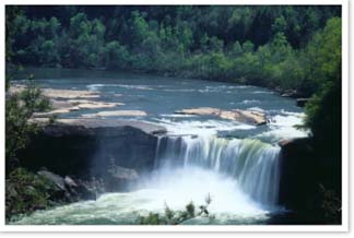
O4 - Cumberland Falls State Resort Park

800-325-0063 Cumberland Falls SRP is located just north of Stearns off of KY 90. *There are lodging, dining and gas opportunities in nearby Corbin.

Cumberland Falls is located near Corbin KY and is the largest waterfall on the Cumberland River. Normally 125 feet wide, its width can increase to 300 feet at flood stage and it varies from 45 to around 70 feet high depending on the height of the pool below the falls. Cumberland Falls is one of only two places in the world (and the only one in the western hemisphere) where you can see a moonbow. The Sheltowee Trace north route runs through the park along the Cumberland River for wildlife viewing "off-road."

Wildlife Viewing Opportunities: Woodpeckers (7 species), red-tailed and broad-winged hawks, and migrant and nesting songbirds, including many warblers. Wildflower lovers will enjoy the wonderful display of spring wildflowers. As in most Kentucky State Parks, deer, raccoon, and squirrel are make the beautiful surrounding of the park their home and can be seen continuously.

O5 – Beaver Creek Wilderness and Wildlife Management Area (WMA)

Travel west on Hwy 192 to Somerset, KY. Turn left onto the 80 Bypass and travel approx. 5 miles to U.S. Hwy 27. Turn left on 27 and travel several miles south to the WMA boundary. A portion of 27 and Highway 90 (left) borders the southern tip of the WMA. Several blacktop and gravel roads are open for access into the WMA, but No Motorized Vehicles are allowed within the boundaries of the Wilderness. Trailheads with vehicle parking are available. Gas, lodging and dining opportunities available in nearby Somerset.

The Beaver Creek Wilderness and Wildlife Management Area in McCreary and Pulaski counties is part of the Daniel Boone National Forest, managed cooperatively with the Kentucky Department of Fish and Wildlife Resources. More than 16,000 acres are managed within the WMA to provide suitable habitat and forage for wildlife. The Wilderness area lies within the boundaries of the WMA, embracing the slopes of Beaver Creek that drains into the Cumberland River. The terrain is steep and rugged, dissected by vertical cliff walls that wind along ridge contours.

Wildlife Viewing Opportunities:
Species to watch for include wild turkeys, white-tailed deer, grouse, quail and, of course, beaver. The dense hardwood forests over varying degrees of elevation provide suitable habitat for numerous breeding songbirds, mammals, reptiles and amphibians. Some of Kentucky’s rare species of bats are known to occur in and around the Beaver Creek area, including the federally listed endangered Indiana bat.
O6 - Rock Creek

Located near Stearns, KY. Traveling south on U.S. Hwy 27, turn right onto Hwy 92. Follow 92 to 1363. Turn left and follow 1363 to Forest Service road 566 (gravel road). Go left to Bell Farm and lower Rock Creek, right to Hemlock Grove, Great Meadow and upper Rock Creek.

The Commonwealth of Kentucky has designated Rock Creek in McCreary County as a State Wild River, and federal designation is currently proposed. Rock Creek drains into the Big South Fork of Cumberland River and offers scenic beauty that only nature can provide. The Bell Farm Horse Camp, Hemlock Grove Picnic Area and Great Meadow campground occur along the Rock Creek corridor. Come and enjoy the tranquil sound of rippling water across the rocks and experience the serenity of this uniquely remote area.

Wildlife Viewing Opportunities: Rock Creek is stocked with rainbow and brown trout during March – December. The dense vegetation along the creek provides excellent cover and nesting opportunities for various species of warblers and other Kentucky songbirds. Great blue herons are often seen fishing along the creek banks, while wild turkeys feed in the fields. Black bears are repopulating this area and may be seen.
O7- Big South Fork Scenic Railway

Trail info: See this wonderland of natural beauty by rail on the Big South Fork Scenic Railway located in Stearns Kentucky. Travel back in time when Stearns was a hub of commerce for the mining and logging industry. Enjoy the sights as you ride the rails and descend some 600 ft in 5 minutes to the Cumberland River valley.

Travel to the Blue Heron Mining Camp, the railroad's stopover point to observe the mine and coal tipple operated by the SC&L Co. It was abandoned in 1962 and restored with "ghost structures" and oral history exhibits in 1989 by the National Park Service as part of the Big South Fork River and Recreation Area. The park contains a gift shop and snack bar with picnic shelter, walking trails and more.

Or ride to the Barthell Mining Camp, named after E.E. Barthell. The mining town served as the coal company's first mine. Abandoned and torn down in 1952, the town has been reconstructed by the Koger family as it looked around 1910.

Wildlife viewing opportunities: Along the scenic railway you will encounter a wide array of birds and wild turkey. White-tailed deer, raccoon, bobcat, gray fox, and gray squirrel will be seen here also. Watch out for the Black Bear, they are starting to filter back to the area.
O8 – Big South Fork National River and Recreation Area

The Kentucky portion is located near Stearns. Gas, lodging and dining opportunities can be sought there.

The free-flowing Big South Fork of the Cumberland River and its tributaries pass through 90 miles of scenic gorges and valleys containing a wide range of natural and historic features. The area offers a broad range of recreational opportunities including camping, whitewater rafting, kayaking, canoeing, hiking, horseback riding, mountain biking, hunting and fishing. The U.S. Army Corps of Engineers, with its experience in managing river basins, was charged with land acquisition, planning and development of facilities. Now completed, these lands and facilities are operated and maintained by the National Park Service for the benefit and use of the public. The Big South Fork was designated as a National River and Recreation Area in 1974.

Habitat and Trail info: The Big South Fork National River and Recreation Area is located in north central Tennessee and southeastern Kentucky in some of the most rugged terrain of the Cumberland Plateau. Big South Fork encompasses approximately 125,000 acres of both rugged forested gorge and adjacent forested plateaus. State and federal lands share the north and western boundary, offering a variety of habitats for both plants and animals. Within the Area many pristine streams, both in Tennessee and Kentucky, flow into the free-flowing Big South Fork of the Cumberland River. Deep gorges carved by eons of erosion have created impressive cliffs and arches throughout the National Area.

The general forest type is mixed-oak with mixed-mesophytic pockets. This is divided into an upland community on the plateau and a ravine community. The upland vegetation types range from Red maple-dominated stands on poorly drained flats to Virginia pine-dominated stands on dry ridges and cliff edges. On the broad flats and gentle slopes are the mixed oaks with hickory. Ravine communities are generally dominated by more mesic species-Beech, Sugar Maple, and Yellow Birch-with oaks on the middle and lower slopes. Hemlock is prominent in the narrow gorges and along streams. River birch and Sycamore typify the floodplains.

Wildlife Viewing Opportunities:
The variety of natural conditions combine to provide a high diversity of habitat. Sixty-eight species of fish and twenty-three species of mussels have been documented in recent surveys within the National Area. About 160 species of birds have been recorded within the Big South Fork NRRA including ruffed grouse, mourning dove, red-tailed hawk, and turkey. Abundant numbers of neotropical birds can be found here including many warbler species. White-tailed deer, raccoon, bobcat, gray fox, and gray squirrel can be seen here. Black bear have been re-introduced to the area.

WMTH Corporation, PO Box 51153, Bowling Green, KY 42102