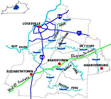
SALT RIVER: The Salt River is a winding, sycamore-lined stream often bordered by medium-sized hills and ridges on one bank and by broad fields or grazing land on the other. Running over a bottom of sandy mud, the Salt is dotted with dozens of small islands. Deadfalls and logjams are numerous and constitute the primary hazards to paddlers. Frequent small rapids, ledges, and waves enliven the paddling but should pose no problems. Current is usually swift, particularly in the winter and spring.
PLUM CREEK: Plum Creek is a tributary of the Salt River which is only runnable after heavy rains. It is unique among high-water streams in that there are practically no deadfalls and the channel is almost uniformly unobstructed. Also, the geology of the riverbed limits lateral erosion and keeps the stream nearly within the confines of its banks even at very high levels.
FLOYDS FORK OF THE SALT RIVER: Floyds Fork rolls alternately beneath steep hills and ridges, and fields and pasture land. The current is swift and the stream is punctuated with small ledges, shoals, and rapids as well as with many brush islands. Dangers to navigation include numerous deadfalls and logjams.
ROLLING FORK OF THE SALT RIVER: Running over a mud and rock bottom, the Rolling Fork meanders along beside broad fields on one side of the stream and rolling hills on the other. Above the mud walls that contain the river, the banks are brushy and treelined. Grass and brush islands are common in the stream. The most scenic section is between the Marion County line and New Haven where the river temporarily departs the farm plains and winds beneath tall, rugged knobs. In this area the precipitous hillsides are densely forested and some exposed rock is visible both in the river gorge and high on the ridges. Navigational dangers are limited to deadfalls, logjams, and several brush islands that necessitate good boat control.
BEECH FORK OF THE ROLLING FORK OF THE SALT RIVER: An extremely winding river, Beech Fork is runnable from November to early June. Treelined and having mud banks of varying steepness while flowing over a mud bottom, the Beech Fork snakes through modest knobs, past distilleries, and on to the broad, gently rolling farm plains of Boston. A collapsed boulder dam one-quarter mile past the US 31E bridge constitutes a Class III+ run with an overall drop of five feet. This rapid can be safely run but changes incredibly with varying water levels and should always be scouted. The rapid is dominated by a vault-sized boulder right in the middle of the river at the bottom of a four-foot drop. To its left (as you look downstream) is a mean hole, particularly at higher water levels. When the water is up there is a nice route on the far left, otherwise, choose your own poison or carry around. Other hazards to navigation include numerous brush islands, deadfall, and some logjams.