Canoeing Topics
Streams of the Jackson Purchase
Streams of the Land Between the Lakes
Streams of the Western Coalfields
Headwaters of the Green River
Salt River System
Ballard Wildlife Management Area
Red River of Logan County
Otter Creek of Meade County
Lower Cumberland River
Harrods Creek
White Water in Kentucky
Also: Canoe Outfitters in Kentucky
Kentucky Kayak Kountry
Home
Maps and info from A Canoeing and Kayaking Guide to the Streams of Kentucky by Bob Sehlinger (used by permission).
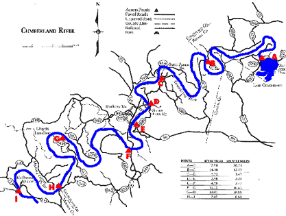
COUNTIES: Russell, Cumberland, Monroe
USGS QUADS: Wolf Creek Dam, Burkesville, Waterview, Blacks Ferry, Vernon, Celina
LEVEL OF DIFFICULTY: International class I Numerical points 5
SUITABLE FOR: Cruising
GRADIENT (feet per mile): 0.60
APPROPRIATE FOR: Families, Beginners, Intermediates, Advanced
VELOCITY (mph): 0-2.5 (2.6-5.0)
AVERAGE WIDTH (ft): 160-290
MONTHS RUNNABLE: All when dam is releasing
MEAN WATER TEMPERATURE (ºF):
SOURCE OF ADDITIONAL INFORMATION ON WATER CONDITIONS:
Corps of Engineers (502) 343-4708, (606) 679-5685
HAZARDS: None
RESCUE INDEX: C
PORTAGES: None required
SCOUTING: None required
INTEREST HIGHLIGHTS: Scenery, geology
SCENERY: Pretty to beautiful in spots
ACCESS POINT AND CODE:
Rescue Index
Access Code
WMTH CORPORATION PO BOX 51153 BOWLING GREEN, KY 42102 PHONE (270) 792-5300 FAX 721-0004