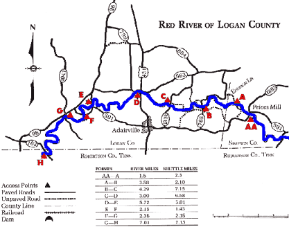
COUNTIES: Simpson, Logan
USGS QUADS: Prices, Mill, Adairville, Dot, Allensville
LEVEL OF DIFFICULTY: International class I Numerical points 4
SUITABLE FOR: Cruising
GRADIENT (feet per mile): 4.28
APPROPRIATE FOR: Families, Beginners, Intermediates, Advanced
VELOCITY (mph): 2.6-5.0
AVERAGE WIDTH (ft): 50-70
MONTHS RUNNABLE: Late Novemer to mid-June
MEAN WATER TEMPERATURE (ºF):
| JAN |
40 |
FEB |
41 |
MAR |
45 |
APR |
55 |
MAY |
66 |
JUN |
77 |
| JUL |
79 |
AUG |
77 |
SEP |
67 |
OCT |
62 |
NOV |
45 |
DEC |
41 |
SOURCE OF ADDITIONAL INFORMATION ON WATER CONDITIONS:
Adairville Police Dept. (270) 539-6131
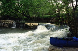
HAZARDS: Deadfalls, low bridges
RESCUE INDEX: C-D
PORTAGES: None required
SCOUTING: None required
INTEREST HIGHLIGHTS: Scenery, wildlife, local culture and industry
SCENERY: Pretty
ACCESS POINT AND CODE:
| AA |
1 3 6 8 9 |
| A |
2 3 5 7 |
| B |
1 3 6 7 |
| C |
1 3 6 8 |
| D |
1 3 6 8 |
| E |
1 3 5 8 |
| F |
1 3 5 7 |
| G |
1 3 6 8 |
| H |
1 3 6 7 |
| KEY |
|
Rescue Index
|
Access Code
|
| K |
Extremely remote; evacuation only with expert help--6 hours to secure assistance |
1 |
Paved Road |
| 2 |
Unpaved Road |
| 3 |
Short Carry |
| L |
Remote; 3-6 hours to secure assistance |
4 |
Long Carry |
| 5 |
Easy Grade |
| 6 |
Steep Grade |
| M |
Accessible but difficult; up to 3 hours to secure assistance-- evacuation difficult |
7 |
Clear Trail |
| 8 |
Brush and Trees |
| 9 |
Private Property, Permission needed |
| N |
Accessible; up to 1 hour to secure assitance, evacuation not difficult |
10 |
Launching Fee Charged |
| 11 |
No Access--Reference Only |