Salt River System -
Rolling Fork KY 52 Bridge to the Salt River

Maps and info from A Canoeing and Kayaking Guide to the Streams of Kentucky by Bob Sehlinger (used by permission).

Rolling Fork KY 52 to the Salt River

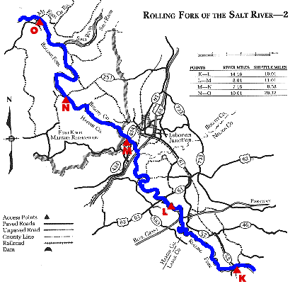
COUNTIES: Nelson, LaRue, Hardin, Bullitt

USGS QUADS: New Haven, Nelsonville, Lebanon Jct.

LEVEL OF DIFFICULTY: International class I    Numerical points 4

SUITABLE FOR: Cruising   

GRADIENT (feet per mile): 2.07

APPROPRIATE FOR: Families, Beginners, Intermediates, Advanced

VELOCITY (mph): 2.6-5.0

AVERAGE WIDTH (ft): 45-65

MONTHS RUNNABLE: November to May

MEAN WATER TEMPERATURE (ºF):

JAN  43 FEB  43 MAR  45 APR  53 MAY  66 JUN  76
JUL  77 AUG  76 SEP 66 OCT 61 NOV 46 DEC 43

SOURCE OF ADDITIONAL INFORMATION ON WATER CONDITIONS:

None available

HAZARDS: Deadfalls, low bridges, Fort Knox Artillery Range

RESCUE INDEX: C

PORTAGES: At small concrete fords

SCOUTING: None required

INTEREST HIGHLIGHTS: Scenery, history, local culture and industry

SCENERY: Pleasant to pretty in spots

ACCESS POINT AND CODE:

K 1 3 5 7
L 1 4 6 8 
M 1 3 6 8 
N 2 3 6 8
O 2 3 6 8
KEY

Rescue Index

Access Code

K Extremely remote; evacuation only with expert help--6 hours to secure assistance 1 Paved Road
2 Unpaved Road
3 Short Carry
L Remote; 3-6 hours to secure assistance 4 Long Carry
5 Easy Grade
6 Steep Grade
M Accessible but difficult; up to 3 hours to secure assistance-- evacuation difficult 7 Clear Trail
8 Brush and Trees
9 Private Property, Permission needed
N Accessible; up to 1 hour to secure assitance, evacuation not difficult 10 Launching Fee Charged
11 No Access--Reference Only

WMTH CORPORATION PO BOX 51153 BOWLING GREEN, KY 42102 PHONE (270) 792-5300 FAX 721-0004