Salt River System -
Salt River Glensboro to Taylorsville

Maps and info from A Canoeing and Kayaking Guide to the Streams of Kentucky by Bob Sehlinger (used by permission).

Salt River Glensboro to Taylorsville Map

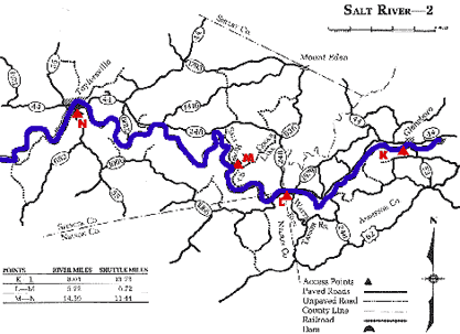
COUNTIES: Anderson, Spencer

USGS QUADS: Glensboro, Ashbrook, Chaplin, Bloomfield, Taylorsville

LEVEL OF DIFFICULTY: International class I+     Numerical points 6

SUITABLE FOR: Cruising

GRADIENT (feet per mile): 2.32

APPROPRIATE FOR: Beginners, Intermediates, Advanced

VELOCITY (mph): 2.6-5.0

AVERAGE WIDTH (ft): 45-65

MONTHS RUNNABLE: November to mid-May

MEAN WATER TEMPERATURE (ºF):

JAN  43 FEB  43 MAR  46 APR  53 MAY  67 JUN  75
JUL  77 AUG  75 SEP 68 OCT 60 NOV 46 DEC 42

SOURCE OF ADDITIONAL INFORMATION ON WATER CONDITIONS:

Corps of engineers (502) 477-8606

HAZARDS: Deadfalls, low bridges, low trees

RESCUE INDEX: C

PORTAGES: None required

SCOUTING: At blind turns for deadfalls

INTEREST HIGHLIGHTS: Scenery, local culture and history

SCENERY: Pretty to pretty in spots

ACCESS POINT AND CODE:

K 1 3 5 7 9
L 1 3 5 8
M 2 3 6 8
N 1 3 5 8
KEY

Rescue Index

Access Code

K Extremely remote; evacuation only with expert help--6 hours to secure assistance 1 Paved Road
2 Unpaved Road
3 Short Carry
L Remote; 3-6 hours to secure assistance 4 Long Carry
5 Easy Grade
6 Steep Grade
M Accessible but difficult; up to 3 hours to secure assistance-- evacuation difficult 7 Clear Trail
8 Brush and Trees
9 Private Property, Permission needed
N Accessible; up to 1 hour to secure assitance, evacuation not difficult 10 Launching Fee Charged
11 No Access--Reference Only

WMTH CORPORATION PO BOX 51153 BOWLING GREEN, KY 42102 PHONE (270) 792-5300 FAX 721-0004