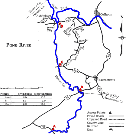
Streams of the Western Coalfields -
Pond River KY 70 to Green River

Maps and info from A Canoeing and Kayaking Guide to the Streams of Kentucky by Bob Sehlinger (used by permission).

Pond River KY 70 to Green River

COUNTIES: Hopkins

USGS QUADS: Millport, Sacramento, Calhoun

LEVEL OF DIFFICULTY: International class I     Numerical points 4

SUITABLE FOR: Cruising, camping (with permission)

GRADIENT (feet per mile): 0.76

APPROPRIATE FOR: Families, Beginners, Intermediates, Advanced

VELOCITY (mph): 0-2.5 (2.6-5.0)

AVERAGE WIDTH (ft): 35-65

MONTHS RUNNABLE: All

MEAN WATER TEMPERATURE (ºF):

JAN  40 FEB  42 MAR  50 APR  55 MAY  65 JUN  74
JUL  76 AUG  75 SEP 68 OCT 61 NOV 49 DEC 41

SOURCE OF ADDITIONAL INFORMATION ON WATER CONDITIONS:

McLean Co. Sheriff Dept. (270) 273-3276

HAZARDS: Deadfalls, powerboats

RESCUE INDEX: B-C

PORTAGES: Around deadfalls in upper sections

SCOUTING: None required

INTEREST HIGHLIGHTS: Scenery, local culture and history

SCENERY: Uninspiring to pretty in spots

ACCESS POINT AND CODE:

A 1 3 6 8
B 1 3 6 8
C 1 3 6 7
D 1 3 5 7
KEY

Rescue Index

Access Code

K Extremely remote; evacuation only with expert help--6 hours to secure assistance 1 Paved Road
2 Unpaved Road
3 Short Carry
L Remote; 3-6 hours to secure assistance 4 Long Carry
5 Easy Grade
6 Steep Grade
M Accessible but difficult; up to 3 hours to secure assistance-- evacuation difficult 7 Clear Trail
8 Brush and Trees
9 Private Property, Permission needed
N Accessible; up to 1 hour to secure assitance, evacuation not difficult 10 Launching Fee Charged
11 No Access--Reference Only

WMTH CORPORATION PO BOX 51153 BOWLING GREEN, KY 42102 PHONE (270) 792-5300 FAX 721-0004