Streams of the Western Coalfields -
Green River Mouth of Pond River to the Ohio River

Maps and info from A Canoeing and Kayaking Guide to the Streams of Kentucky by Bob Sehlinger (used by permission).

Green River Mouth of Pond River to the Ohio River Map

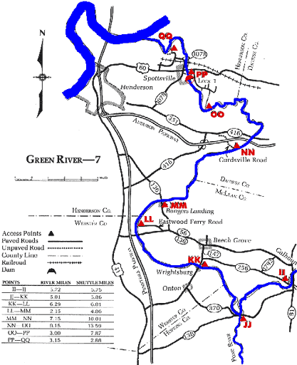
COUNTIES: Hoplins, WEbster, McLean, Henderson, Daviess

USGS QUADS: Calhoun, Beech Grove, Delaware, Curdsville, Reed, Spottsville, Newburgh

LEVEL OF DIFFICULTY: International class I     Numerical points 4

SUITABLE FOR: Cruising

GRADIENT (feet per mile): 0.40

APPROPRIATE FOR: Families, Beginners, Intermediates, Advanced

VELOCITY (mph): 2.6-5.0

AVERAGE WIDTH (ft): 150-210

MONTHS RUNNABLE: All

MEAN WATER TEMPERATURE (ºF):

JAN  46 FEB  46 MAR  50 APR  55 MAY  68 JUN  77
JUL  80 AUG  79 SEP 76 OCT 67 NOV 56 DEC 45

SOURCE OF ADDITIONAL INFORMATION ON WATER CONDITIONS:

Corps of Engineers, Lock 2 (270) 273-3152

HAZARDS: Dams, powerboats

RESCUE INDEX: C-D

PORTAGES: Lock Nos. 2 (Rumsey) and 1 (Spottsville)

SCOUTING: None required

INTEREST HIGHLIGHTS: Scenery, history, local culture and industry

SCENERY: Pleasant in spots to pretty in spots

ACCESS POINT AND CODE:

II 1 3 6 7
JJ 1 3 5 7
KK 1 3 5 7
LL 1 3 5 7
MM 1 3 5 7
NN 2 3 6 7
OO 2 3 5 7
PP 1 3 5 7
QQ 2 3 5 7
KEY

Rescue Index

Access Code

K Extremely remote; evacuation only with expert help--6 hours to secure assistance 1 Paved Road
2 Unpaved Road
3 Short Carry
L Remote; 3-6 hours to secure assistance 4 Long Carry
5 Easy Grade
6 Steep Grade
M Accessible but difficult; up to 3 hours to secure assistance-- evacuation difficult 7 Clear Trail
8 Brush and Trees
9 Private Property, Permission needed
N Accessible; up to 1 hour to secure assitance, evacuation not difficult 10 Launching Fee Charged
11 No Access--Reference Only

WMTH CORPORATION PO BOX 51153 BOWLING GREEN, KY 42102 PHONE (270) 792-5300 FAX 721-0004