Streams of Land Between the Lakes -
Tennessee River Dam to Mouth of Clarks River

Maps and info from A Canoeing and Kayaking Guide to the Streams of Kentucky by Bob Sehlinger (used by permission).

Tennessee and Cumberland Rivers to Ohio River Map

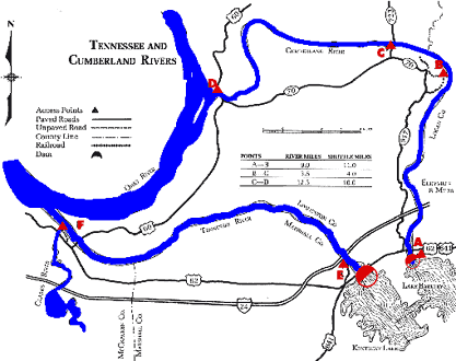
COUNTIES: Marshall, McCracken

USGS QUADS: Calvert City, Little cypress, Paducah East

LEVEL OF DIFFICULTY: International class I     Numerical points 5

SUITABLE FOR: Cruising

GRADIENT (feet per mile): 0.27

APPROPRIATE FOR: Beginners, Intermediates, Advanced

VELOCITY (mph): 0-2.5

AVERAGE WIDTH (ft): 220-340

MONTHS RUNNABLE: All

MEAN WATER TEMPERATURE (ºF):

JAN  45 FEB  48 MAR  50 APR  56 MAY  65 JUN  76
JUL  81 AUG  81 SEP 73 OCT 69 NOV 53 DEC 46

SOURCE OF ADDITIONAL INFORMATION ON WATER CONDITIONS:

Kentucky Lake Locks (270) 362-4221

HAZARDS: Powerboats

RESCUE INDEX: C

PORTAGES: None required

SCOUTING: None required

INTEREST HIGHLIGHTS: Scenery, local culture and industry

SCENERY: Pleasant to pretty in spots

ACCESS POINT AND CODE:

E 1 3 5 7
F 1 3 5 7
KEY

Rescue Index

Access Code

K Extremely remote; evacuation only with expert help--6 hours to secure assistance 1 Paved Road
2 Unpaved Road
3 Short Carry
L Remote; 3-6 hours to secure assistance 4 Long Carry
5 Easy Grade
6 Steep Grade
M Accessible but difficult; up to 3 hours to secure assistance-- evacuation difficult 7 Clear Trail
8 Brush and Trees
9 Private Property, Permission needed
N Accessible; up to 1 hour to secure assitance, evacuation not difficult 10 Launching Fee Charged
11 No Access--Reference Only

WMTH CORPORATION PO BOX 51153 BOWLING GREEN, KY 42102 PHONE (270) 792-5300 FAX 721-0004