Stream of the Jackson Purchase -
Mayfield Creek East of Hickory to KY 121

Maps and info from A Canoeing and Kayaking Guide to the Streams of Kentucky by Bob Sehlinger (used by permission).

Mayfield Creek East of Hickory to KY 121 Map

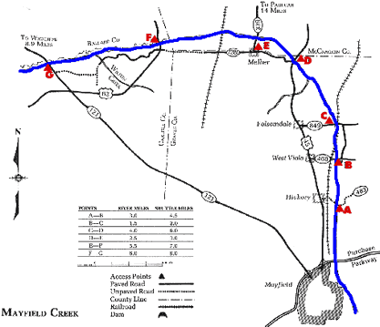
COUNTIES: Graves, Carlisle, McCracken

USGS QUADS: Westplains, Hickory, Melber, Lovelaceville, Blandville, Wickliffe

LEVEL OF DIFFICULTY: International class I     Numerical points 6

SUITABLE FOR: Cruising

GRADIENT (feet per mile): 3.75

APPROPRIATE FOR: Beginners, Intermediates, Advanced

VELOCITY (mph): 0-2.5

AVERAGE WIDTH (ft): 40-60

MONTHS RUNNABLE: Late fall to early summer

MEAN WATER TEMPERATURE (ºF):

JAN  44 FEB  43 MAR  47 APR  56 MAY  65 JUN  73
JUL  76 AUG  76 SEP 74 OCT 61 NOV 53 DEC 44

SOURCE OF ADDITIONAL INFORMATION ON WATER CONDITIONS:

Mayfield City Hall (270) 247-1971

HAZARDS: Deadfalls, low trees, flash floods

RESCUE INDEX: C

PORTAGES: Around deadfalls

SCOUTING: None required

INTEREST HIGHLIGHTS: Scenery, wildlife

SCENERY: Pretty to beautiful in spots

ACCESS POINT AND CODE:

A 2 3 6 7
B 1 3 6 8
C 1 3 6 8
D 1 3 6 8
E 1 3 6 7
F 1 3 6 8
G 1 3 6 8
KEY

Rescue Index

Access Code

K Extremely remote; evacuation only with expert help--6 hours to secure assistance 1 Paved Road
2 Unpaved Road
3 Short Carry
L Remote; 3-6 hours to secure assistance 4 Long Carry
5 Easy Grade
6 Steep Grade
M Accessible but difficult; up to 3 hours to secure assistance-- evacuation difficult 7 Clear Trail
8 Brush and Trees
9 Private Property, Permission needed
N Accessible; up to 1 hour to secure assitance, evacuation not difficult 10 Launching Fee Charged
11 No Access--Reference Only

WMTH CORPORATION PO BOX 51153 BOWLING GREEN, KY 42102 PHONE (270) 792-5300 FAX 721-0004