Barren River Mouth of Drakes Creek to Green River

Maps and info from A Canoeing and Kayaking Guide to the Streams of Kentucky by Bob Sehlinger (used by permission).

Barren River Mouth of Drakes Creek to Green River Map

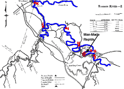
COUNTIES: Butler, Warren

USGS QUADS: Bowling Green South, Bowling Green North, Hadley, Riverside

LEVEL OF DIFFICULTY: International class I(III)     Numerical points 4

SUITABLE FOR: Cruising, camping

GRADIENT (feet per mile): 0.686

APPROPRIATE FOR: Families, Beginners, Intermediates, Advanced

VELOCITY (mph): 0-2.5

AVERAGE WIDTH (ft): 90-150

MONTHS RUNNABLE: All

MEAN WATER TEMPERATURE (ºF):

JAN  46 FEB  47 MAR  51 APR  57 MAY  67 JUN  75
JUL  77 AUG  76 SEP 70 OCT 61 NOV 48 DEC 44

SOURCE OF ADDITIONAL INFORMATION ON WATER CONDITIONS:

Corps of Engineers (270) 646-2055

HAZARDS: Dams, deadfalls, powerboats, man-made rapid at Bowling Green

RESCUE INDEX: C

PORTAGES: Lock No. 1 at Greencastle and possibly man-made rapid in Bowling Green

SCOUTING: At rapid

INTEREST HIGHLIGHTS: Scenery, local culture and industry

SCENERY: Pleasant to pretty

ACCESS POINT AND CODE:

F 1 3 5 7
G 1 3 5 7
H 1 3 5 7
I 1 3 5 7
J* 1 3 6 7
K** 1 3 5 7
* Put-in or take-out on Gasper River
* Take-out only on Green River
KEY

Rescue Index

Access Code

K Extremely remote; evacuation only with expert help--6 hours to secure assistance 1 Paved Road
2 Unpaved Road
3 Short Carry
L Remote; 3-6 hours to secure assistance 4 Long Carry
5 Easy Grade
6 Steep Grade
M Accessible but difficult; up to 3 hours to secure assistance-- evacuation difficult 7 Clear Trail
8 Brush and Trees
9 Private Property, Permission needed
N Accessible; up to 1 hour to secure assitance, evacuation not difficult 10 Launching Fee Charged
11 No Access--Reference Only

WMTH CORPORATION PO BOX 51153 BOWLING GREEN, KY 42102 PHONE (270) 792-5300 FAX 721-0004