Barren River Dam to Mouth of Drakes Creek

Maps and info from A Canoeing and Kayaking Guide to the Streams of Kentucky by Bob Sehlinger (used by permission).

Barren River Dam to Mouth of Drakes Creek Map

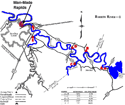
COUNTIES: Barren, Allen, Warren

USGS QUADS: Lucas, Meador, Polkville, Bowling Green South

LEVEL OF DIFFICULTY: International class I     Numerical points 6

SUITABLE FOR: Cruising, camping

GRADIENT (feet per mile): 1.33

APPROPRIATE FOR: Famlies, Beginner, Intermediate, Advanced

VELOCITY (mph): 0-2.6 (2.6-5.0)

AVERAGE WIDTH (ft): 40-60

MONTHS RUNNABLE: All when dam is releasing

MEAN WATER TEMPERATURE (ºF):

JAN  45 FEB  46 MAR  50 APR  56 MAY  66 JUN  74
JUL  76 AUG  76 SEP 69 OCT 60 NOV 48 DEC 44

SOURCE OF ADDITIONAL INFORMATION ON WATER CONDITIONS:

Corps of Engineers (270) 646-2005

HAZARDS: Deadfalls

RESCUE INDEX: C

PORTAGES: None required

SCOUTING: None required

INTEREST HIGHLIGHTS: Scenery

SCENERY: Pretty to pretty in spots

ACCESS POINT AND CODE:

A 1 3 5 7
B* 1 3 6 7
C 1 3 6 8
D 1 4 6 7
E** 1 3 6 8
F 1 3 5 7
*Put in only at Bays Fork
**Put in only at Drakes Creek
KEY

Rescue Index

Access Code

K Extremely remote; evacuation only with expert help--6 hours to secure assistance 1 Paved Road
2 Unpaved Road
3 Short Carry
L Remote; 3-6 hours to secure assistance 4 Long Carry
5 Easy Grade
6 Steep Grade
M Accessible but difficult; up to 3 hours to secure assistance-- evacuation difficult 7 Clear Trail
8 Brush and Trees
9 Private Property, Permission needed
N Accessible; up to 1 hour to secure assitance, evacuation not difficult 10 Launching Fee Charged
11 No Access--Reference Only

WMTH CORPORATION PO BOX 51153 BOWLING GREEN, KY 42102 PHONE (270) 792-5300 FAX 721-0004