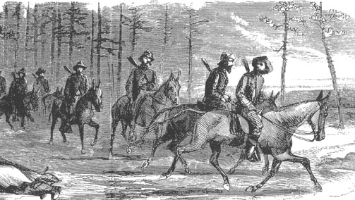
The Great Raid - July 3,1863 After engaging Union forces in Columbia the afternoon of July 3,Gen.John Hunt Morgan’s command continued north on the Columbia-Lebanon Pike. Just beyond the town, they passed Union Camp Gilbert, formerly named Camp Boyle, now abandoned -the site marked by a telegraph line, tents,and a few men powerless to stop 2,400 raiders thundering toward Cane Valley, seven miles north.
Many of the Raiders had abandoned their horses in Columbia, taking fresh mounts without consent of their owners. They took whatever supplies they could,including whiskey and money, because there was no supply train to provide for them. Farmers and shopkeepers had their storehouses emptied. Lt.Col.Robert Alston, Morgan’s chief of staff, considered such behavior appalling and remarked that some men accompanied the army simply for plunder.
Morgan and the majority of his men were Kentuckians who knew “secesh ” sympathizers willing to provide camp sites... That night the troops camped in the fields near the Cane Valley house of Morgan’s friends, the Bridgewaters; their general slept in a bed in the house, waited on by his servant, Old Box.
Lt.Richard Archibald Webster - In his haste to move on, Morgan left his coat at the Bridgewater house according to Mary Page, a Bridgewater granddaughter, who wrote that the coat was cut up and given to people as souvenirs. While in Cane Valley Morgan called on Lt. Richard Archibald “Dick Archie” Webster of Taylor County to help lead the men toward Lebanon. Although scouts reported about 400 Union soldiers fortifying the Green River at Tebbs Bend, Morgan was unconcerned, secure in the knowledge that his troops were superior in number with a battery of artillery. At 3:00 a.m. the next morning the Confederates headed toward the Green River bridge.
Directional Signage:
225 Cane Valley Road (Adair County off Hwy 55 N)
Cane Valley Road is part of the original Columbia - Campbellsville Toll Road. It is the way the Raiders would have gone. The present Campbellsville Road was built in the 1920s.
From Columbia, going north on 55N (Campbellsville Road), turn right on Hwy 530 (3.3 miles from junction 206). Continue following the road 2 miles to the sign on the right side of the road beside the Christian Church. Exit at the next left (Cane Valley School Road) on to 55N (Campbellsville Road).
From Campbellsville, going south on 55 - Campbellsville Road - also called New Columbia Road, look for the yellow diamond shaped crossroad sign, take the next left turn onto Cane Valley School Road. Turn right at the junction with Cane Valley Road. Sign is just past the antique shop and by the church parking lot on the left. Continue past the church going south until the road turns right onto Hwy 55 (Campbellsville Road) and go to Columbia.
WMTH CORPORATION PO BOX 51153 BOWLING GREEN, KY 42102 PHONE (270) 792-5300 FAX 721-0004