Numerous places to hike in Buchanan County. There are several parks in Grundy with walking & hiking trails. Breaks Interstate Park has 16 hiking trails that cover over 25 miles of terrain with varying degrees of difficulty.
Breaks Interstate Park – “Grand Canyon of the South”, was created in 1954 by joint action of the Kentucky and Virginia legislatures encompassing 4,500 acres of green woodlands and sky scraping mountain scenery. Outdoor recreation abounds within the park – swimming, camping, picnicking, hiking, unusual geological formations, hidden springs, caves, horseback riding, lodge, fishing, boating, whitewater rafting, wildlife & bird viewing and much more. For more information about the Appalachian Plateau, click here.
Kiwanis Park Grundy, VA (540) 935-2204
The Kiwanis Park in Grundy features picnic facilities, a walking track, a covered stage, playground equipment and a tennis court.
DICKENSON
George Washington/Jefferson National Forest
Headquarters, 5162 Valleypointe Parkway, Roanoke, VA 24019 (540) 265-5100
U.S. National Forests combined to form one of the largest areas of public land in the Eastern United States. They cover 1.8 million acres of land in the Appalachian Mountains of Virginia, West Virginia, and Kentucky. This dynamic forest duo is home to over 500 species of trees and plants, including oaks, hickory, maple and pine. Wildlife watchers and nature lovers should stay alert for glimpses of black bears, white-tailed deer, bobcats, bald eagles, weasels, otters, and Martens. Everyone will enjoy mountain biking and hiking. For more information about trails, fishing and other recreational offerings in the Washington/Jefferson National Forest, click here.
Breaks Interstate Park State Route 80, Breaks, VA 24607
(276) 865-4413 “Grand Canyon of the South”, was created in 1954 by joint action of the Kentucky and Virginia legislatures encompassing 4,500 acres of green woodlands and sky scraping mountain scenery. Outdoor recreation abounds within the park – swimming, camping, picnicking, hiking, unusual geological formations, hidden springs, caves, horseback riding, lodge, fishing, boating, whitewater rafting, wildlife & bird viewing and much more. For more information about the Appalachian Plateau, click here.
Birch Knob Observation Tower – elevation of 3,144 feet above sea level. The tower view is well worth the trek of 100 yard walk from the parking lot and the 183 stair steps. Don’t forget a camera and a bottle of water – you are going to be there awhile. One can see Kentucky, West Virginia, Virginia, North Carolina and Tennessee. Access Pine Mountain Trail. www.dickensonctyva.com
John W. Flannagan Dam & Reservoir Cumberland Mountains of Dickenson County, VA
Route 1, Haysi, VA 24256 (276) 835-9544 The lake stores the waters of the Cranesnest and Pound Rivers. Provides flood control, low-flow augmentation, fish & wildlife enhancement, water supply and recreation. The dam, spillway and outlet construction was completed in 1964 with the dam measuring 250 feet high and 916 feet long forming an 1,145 acre lake behind the dam with almost 40 miles of shoreline. 3 campgrounds, five boat ramps, picnic areas, fishing, hiking, hunting, boating and picnic shelters. Swimming is available along certain sections of the lake. www.dickensonctyva.com
Pine Mountain Trail Main Street, Clintwood, VA 24228
(276) 926-4605 Scenic hiking/horseback riding trail following the crest of the Cumberland Mountains.
LEE
George Washington/Jefferson National Forest
Headquarters, 5162 Valleypointe Parkway, Roanoke, VA 24019 (540) 265-5100 U.S. National Forests combined to form one of the largest areas of public land in the Eastern United States. They cover 1.8 million acres of land in the Appalachian Mountains of Virginia, West Virginia, and Kentucky. This dynamic forest duo is home to over 500 species of trees and plants, including oaks, hickory, maple and pine. Wildlife watchers and nature lovers should stay alert for glimpses of black bears, white-tailed deer, bobcats, bald eagles, weasels, otters, and Martens. Everyone will enjoy mountain biking and hiking. For more information about trails, fishing and other recreational offerings in the Washington/Jefferson National Forest, click here.
The Wilderness Road Trail - One of the nation's most historic routes, the Daniel Boone Wilderness Trail was blazed by the legendary frontiersman in 1775 at what is now Kingsport, TN, through the Cumberland Gap of Virginia (Lee County) and into Kentucky. It would become the route for hundreds of thousands of settlers of the western frontier. The state park is about 310 acres that lie astride the Wilderness Road. A 10-mile hiking, biking and equestrian trail. Indian Ridge Trail, a self-guided, natural heritage trail. Wilderness Road Trail bisects Wilderness Road State Park. Visitors may park cars and horse trailers at the park to access the trail. The trail connects the park with the campgrounds at Cumberland Gap National Historical Park, six miles away. 800-933-PARK. Click here for a map of the trail.
Wilderness Road State Park Rt. 2, Ewing, VA
(276) 445-3065 or (800) 933-PARK
Website: www.dcr.virginia.gov/state_parks/wil.shtml One of Virginia’s newest state parks. About 200 acres are open for picnicking, hiking and living history programs. One can enjoy the reconstructed Martin’s Station, an outdoor living history museum depicting life on Virginia’s 1775 frontier or hike the 12-mile Wilderness Road Trail linking the park with the 50 miles of trails within the Cumberland Gap National Historical Park. Unique regional gifts are available at the Wilderness Road Outpost. The park offers seasonal living history programs depicting life in the mid-1700s. 200 acres for picnicking, hiking and living history programs, visitor center, frontier museum, picnic shelters, playground, seasonal living history programs.
Cumberland Gap National Historic Park
Headquarters: P.O. Box 1848, Middlesboro, KY 40965
(606) 248-2817 At Cumberland Gap, the first great gateway to the west, follow the buffalo, the Native American, the longhunter, the pioneer... all traveled this route through the mountains into the wilderness of Kentucky. Modern day explorers and travelers stand in awe at this great gateway and the many miles of trails and scenic features found in the park. Historic buildings and sites throughout the park provide opportunities to take a close look at the events that shaped a region and a nation. Scenic vistas, cascading waterfalls, and lush forests excite the senses and provide the opportunity to experience the Southern Appalachians up close. The forests and streams of the mountains provide habitat for numerous species of plants and animals. 70 miles of trails and numerous scenic areas provide the opportunity to explore the great outdoors!
Leeman Field Park 605 Old Zion Road, Pennington Gap, VA 24277
(276) 546-1177 or (276) 546-1179
Website: www.townofpennington.com Tennis courts, basketball courts, volleyball courts, a .58 mile walking trail, 2 children's playgrounds, a sand box, swimming pool, baseball fields, access to the Powell River, and 3 pavilions.
CITY OF NORTON
Flag Rock Recreation Area & Campground 618 Virginia Avenue, Norton, VA 24273
(276) 679-0754 Rock outcrop capped with an American Flag, thus the name "Flag Rock". The recreation site sits over 1,000 feet above the City's elevation of 2,350 ft. offers twenty-five acres of recreation area with spectacular views, hiking trails, a fishing area, playground equipment and 18 camping slots. Bath houses have hot and cold water. Two large shelters and several smaller ones are available for picnicking. There are over 50 picnic tables with grills. Primitive camping is also available. Two large shelters are available.
Clear Creek Park 618 Virginia Ave., Norton, VA 24273
(276) 679-0754 Clear Creek Park is a four acre park and includes a playground, a basketball court, a shelter, walking track, and softball field.
RUSSELL
Mount Rogers National Recreation Area There are over 400 miles of designated trails ranging from primitive single-track to old logging roads and railroad grades. Some are for foot only, others allow horse and/or bicycle use. Use only those trails open to your particular type of travel. Note that trails within wildernesses are always primitive. Any type of motorized or wheeled vehicles (including bicycles and any type of wheeled cart) is prohibited in wilderness, but horses are allowed on designated trails. There are also two small lakes, more than 100 miles of tumbling trout streams (both stocked and native), a 66-mile horse trail, three federal wilderness areas, seven car campgrounds, and Virginia's highest automobile road which permits nonwalkers to savor the spectacular views from Whitetop Mountain. At 5,540 feet, Whitetop is the second highest mountain in Virginia.
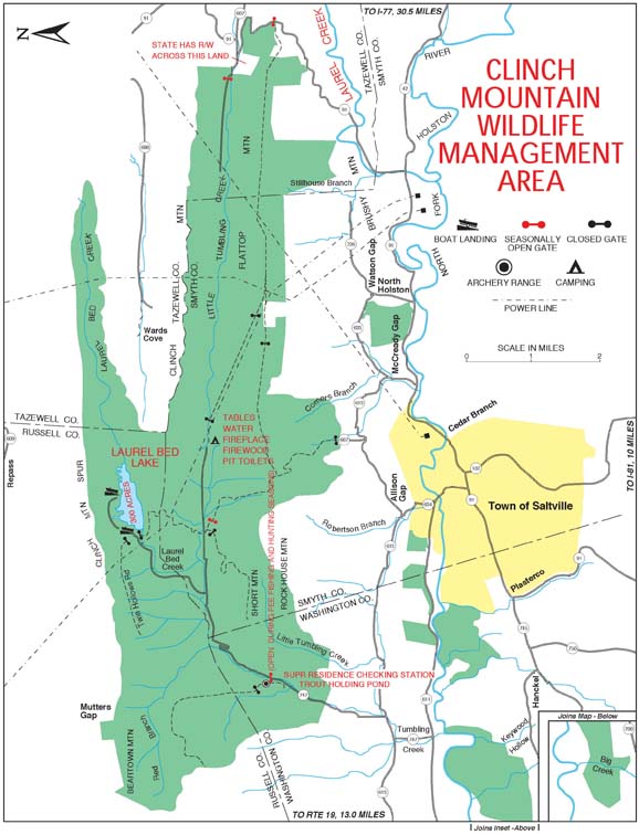
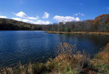
The Clinch Mountain Wildlife Management Area Click here for a map of the WMA. Due to difference in elevation a unique forest had developed. Tree species from both southern and northern forests are found. Elevations range from 1600 feet to 4700 feet atop Beartown Mountain. There is considerable water on the area; a 330-acre man-made lake, one major stream and several tributaries. The land that forms Clinch Mountain Wildlife Management Area was virgin forest until the late 1800's. Evidence of the narrow gauge railroad used during logging can still be seen, and some of the old rail bed is now part of the management area's present road system. Hunting: deer, bear, turkey, grouse, gray and fox squirrel, rabbit, beaver, excellent waterfowl habitat & wood duck. Fishing: brook trout fishery, smallmouth and rock bass. Other popular uses of the area include: horseback riding, wildlife viewing, hiking, and nature photography. A wide range of wildflowers attract visitors in the spring.
Hidden Valley Lake Wildlife Management Area Click here for a map of the WMA. Located along Washington County and bordering on Russell County. Hunting: deer, bear, turkey, squirrel, grouse, deer and bear. Fishing: smallmouth bass, rock bass, bluegill, northern pike and walleye. Hiking, photography.
Pinnacle Natural Area Preserve Hungry Mother State Park, 2854 Park Boulevard, Marion, VA 24354 (276) 762-5297 Offers birding and wildlife watching, hiking, self-guided trails, restrooms. The preserve lands provide suitable habitate for rare or declining plant and animal species, natural communities, some types of which are rare and some of which are found nowhere else on earth. Natural settings.
Slates Campground/Picnic Area – private campground with electric, water, and cable TV hookups. Located on the Clinch River. 2 mile hiking trail for hiking, birding and wildflower walks. Blackford.
J.S. Easterly Park P.O. Box 926, Lebanon, VA 24266 (540) 899-8041 This county park is landmarked by a crystal-clear waterfall. For a pleasant walk, the park offers hiking trails, or try a leisurely afternoon of tennis.
SCOTT
George Washington/Jefferson National Forest Headquarters 5162 Valleypointe Parkway, Roanoke, VA 24019 (540) 265-5100 U.S. National Forests combined to form one of the largest areas of public land in the Eastern U.S.. Covers 1.8 million acres of land in the Appalachian Mountains of Virginia, West Virginia, & Kentucky. This dynamic forest duo is home to over 500 species of trees and plants, inc. oaks, hickory, maple and pine. Wildlife watchers/nature lovers should stay alert for glimpses of black bears, white-tailed deer, bobcats, bald eagles, weasels, otters, and Martens. Enjoy mountain biking and hiking. In Scott County, the forest borders the northern end of the county and offers 93,000 acres of recreational possibilities such as mountain stream trout fishing, camping, hiking, nature observation and hunting. For more info about offerings in the National Forest, click here. For more information about the Appalachian Plateau, click here.
Wilderness Road Trail Wilderness Road State Park, Rt. 2, Ewing, VA 24248 (276) 445-3065 or (800) 933-PARK Part of the famous Wilderness Road Trail blazed by Daniel Boone in the 1780's and traveled by over 300,000 settlers heading west. It is a 10-mile biking, hiking and equestrian trail. Travels through Scott county. This route was established in 1775 and was traveled by over 300,000 settlers as they discovered America’s First Frontier. A driving tour is available to trace this historic route with points of interest located along the way. Click here for a map of the trail. www.danielboonetrail.com
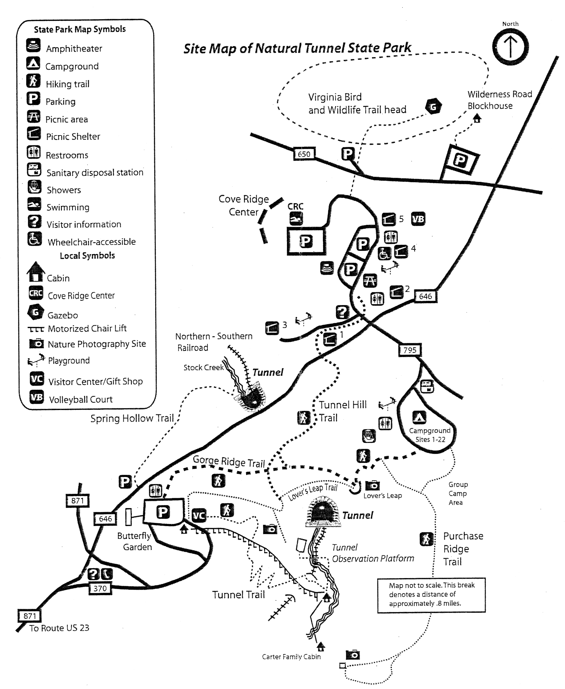
Natural Tunnel State Park & Campground 1420 Natural Tunnel Parkway, Duffield, VA 24244 (276) 940-2674 Was naturally carved through limestone ridges over thousands of years. More than 850 feet long and as high as a ten story building. It has been called the eighth wonder of the world. Other features: wide chasm between steep stone walls surrounded by pinnacles or chimneys. Campground, picnic areas, amphitheather, visitor center, gift shop, blockhouse, swimming pool and chair lift to the tunnel floor. Cave tours and canoe trips on the Clinch River. Home to the Cove Ridge Center for environmental education which has conference facilities and overnight dorm accommodations. Click here for a Natural Tunnel SP Site Map.
Scott County Park Rt. 2, Box 968, Gate City, VA 24251 (276) 452-4442 Park includes a 9-hole golf course, pro shop, 6 picnic shelters, 2 tennis courts, tetherball, game room with ping pong & foosball, walking trail, horseshoe pits
Keith Memorial Park Nichelsville, VA Playgrounds, picnic area, Nickelsville Community Center has space for meetings, reunions and special events. Baseball field, little league baseball fields, walking trail, rest station with restrooms, concessions, War Memorial, basketball court, ampitheatre with seating
Duffield Community Park Duffield, VA 3 lighted tennis courts, baseball/teeball field, softball field, walking trail, picnic areas, beach/sand volleyball, basketball courts, concessions, restrooms, playgrounds with fitness stations.
Weber City Recreation Complex Weber City, VA 4 lighted tennis courts, beach/sand volleyball, tee ball, playground, walking trail, picnic areas, basketball courts, concessions, fitness stations.
TAZEWELL
George Washington/Jefferson National Forest Headquarters
For More Information, Contact: 5162 Valleypointe Parkway, Roanoke, VA 24019 (540) 265-5100 U.S. National Forests combined to form one of the largest areas of public land in the Eastern United States. They cover 1.8 million acres of land in the Appalachian Mountains of Virginia, West Virginia, and Kentucky. This dynamic forest duo is home to over 500 species of trees and plants, including oaks, hickory, maple and pine. Wildlife watchers and nature lovers should stay alert for glimpses of black bears, white-tailed deer, bobcats, bald eagles, weasels, otters, and Martens. Everyone will enjoy mountain biking and hiking. For more information about trails, fishing and other recreational offerings in the Washington/Jefferson National Forest, click here.
Cavitt's Creek Park/Lake Camping 315 School Street, Tazewell, VA 24651 (276) 988-7250 The 54 acre lake is part of the 164 acre Cavitt's Creek Park. Lake Witten is classified as a "Class A" lake. The Virginia Game Commission stocks trout nine times during the year. Open for fishing, camping, picnicking, hiking and boating (only electric motor boats are permitted). Nine full service RV/camper sites, laundry room/bathhouse, primitive camping spaces and full service campsites are available. Boats and paddle boats are also available for rent. Wildlife viewing, biking and birding trails. 7 picnic shelters with a large playground.
Laurel Meadows Park Pocahontas, VA 7 acre park with 1/2 mile walkway, caboose, pavilions and playground equipment
J. Witten Recreation Area 315 School Street, Tazewell, VA 24651 (276) 988-7250 Lake Witten is classified as a "Class A" lake. The Virginia Game Commission stocks trout nine times a year. Open for fishing, camping, picnicking, hiking and boating (only electric motor boats are permitted). The campground has 12 spaces for recreational vehicles but has no electrical hookups. Primitive camping spaces are also available. Boats and paddleboats are available for rent.
Richlands. West on Hwy 460. Refreshing mix of industrial property and country living. Unique dining, entertainment, varied shpping (boutiques, gifts, crafts, plazas) and an active regional farmers market. Hiking, walking, biking, fishing and hunting. Richlands Recreation Park and Clinch River Walking Trail are pleasant and Critterville is a great park for young children.
WISE
George Washington/Jefferson National Forest Headquarters 5162 Valleypointe Parkway, Roanoke, VA 24019 (540) 265-5100 U.S. National Forests combined to form one of the largest areas of public land in the Eastern United States. They cover 1.8 million acres of land in the Appalachian Mountains of Virginia, West Virginia, and Kentucky. Forest duo is home to over 500 species of trees and plants, including oaks, hickory, maple and pine. Wildlife watchers and nature lovers should stay alert for glimpses of black bears, white-tailed deer, bobcats, bald eagles, weasels, otters, and Martens. Everyone will enjoy mountain biking and hiking. For more information about trails, fishing and other recreational offerings in the Washington/Jefferson National Forest, click here.
Chief Benge Trail 9416 Darden Drive, Jefferson Naitonal Forest, Wise, VA 24293 (276) 328-2931 18.7 mile trail for experienced hikers through the Jefferson National Forest.
Devil's Fork Trail System 9416 Darden Drive, Wise, VA 24293 (540) 328-2931 Hiking trail. Old logging grade. 20' waterfall, mountain overlooks and the Devil's Bathtub.
High Knob Lake Trail 9416 Darden Drive, Jefferson National Forest, Wise, VA 24293 (276) 328-2931 1.3 mile trail that leads to High Knob Lake.
Lake Keokee Loop Trail 9416 Darden Drive, Jefferson National Forest, Wise, VA 24293 (276) 328-2931 3.7 mile trail around the 92 acre lake. Hiking, fishing, & wildlife watching
Laurel Fork Trail 9416 Darden Drive, Jefferson National Forest, Wise, VA 24293 (276) 328-2931 Camping, picnicking, scenic with small waterfalls. 1.5 miles long
Little Stony National Recreation Trail 9416 Darden Drive, Jefferson National Forest, Wise, VA 24293 (276) 328-2931 2.8 mile trail follows the stream through a 400 ft. deep and 1.700 ft. wide gorge. Two waterfalls and the Hanging Rock Picnic Area. Fishing is allowed.
Phillips Creek Loop Trail 9416 Darden Drive, Jefferson National Forest, Wise, VA 24293 (276) 328-2931 Self-guided trail that comes with a narrative trail brochure. Wildlife clearing where one may see deer, turkey and other wild game. Old homestead, waterfalls. 1.3 miles
Stone Mountain Trail 9416 Darden Drive, Jefferson National Forest, Wise, VA 24293 (276) 328-2931 14.3 miles. Miniature falls amidst interesting rock formations. Stand of old growth hemlock over 300 years old. Lots of rock outcrops and rock formations for scenic value. Difficult hike because of the length and unevn footing.
Straight Fork Ridge Trail 9416 Darden Drive, Jefferson National Forest, Wise, VA 24293 (276) 328-2931 2 mile hike has many scenic vistas to enjoy looking over the mountain.
Wallen Ridge Trail 9416 Darden Drive, Jefferson National Forest, Wise, VA 24293 (276) 328-2931 6.9 mile trail travels along the top of Wallen Ridge to an area just west of Mountain Empire Community College.
Bark Camp Recreation Area/Camping 9416 Darden Drive, Wise, VA 24293 (540) 328-2931 The camp offers 25 camping units with tent pad, picnic table and parking spur near 60 acre warm water lake which provides opportunities for fishing and boating (electric motors only). Paved boat launching ramp, hiking trails and picnic units with tables and grills are also featured.The lake is stocked with northern pike, bass, blue gill, rainbow trout and catfish.
Bulitt Park 103 Shawnee Ave., Big Stone Gap, VA 24219 (276) 523-0115 Is the largest of nine community parks. Includes a football field, tennis courts, fitness and biking trails, large playground area, picnic area, and a track.
Cave Springs Campground 9416 Darden Drive. Wise, VA 24293 (276) 328-2931 One of the largest campgrounds in the Jefferson National Forest. Small lake for swimming, fed by a spring that originates in the mountains above the cave. Hiking trails are developed in the area. 41 camping sites with electrical hookup.
Devil's Bathtub & Waterfall 9416 Darden Drive, Jefferson National Forest, Wise, VA 24293 (276) 328-2931 Hikers can see a stream racing down a rock chute, swirl through the "tub" and race downstream.
North Fork Reservoir - Cane Patch Camping U.S. Army Corps of Engineers, Rt. 1, Pound, VA 24279 (276) 796-5775 154 Acre Lake is used for fishing, boating, camping, picnicking, and hiking. 33 campsites with restrooms, showers and playground equipment. Fish species include: largemouth bass, crappie, catfish, and sunfish.
Whispering Pines Family Campground Birchfield Road RT. 759, Wise, VA 24293 (276) 328-6876 160 acres. Fuly equipped RV sites and primitive tent sites. Includes a dumping station, bathhouse, swimming lake, hiking trails, volleyball, basketball and other recreational facilities.
Big Stone Gap 619 Gilley Ave., Big Stone Gap, VA 24219 (276) 523-2060 Many of the town's attractions are featured in Adriana Trigiani's books, Big Stone Gap, Big Cherry Holler and Milk Glass Moon. Just as in the book, this is a lovely, Victorian-era town. Walking/driving tour of attractions, buildings, historical landmarks and Victorian-era homes.
WMTH CORPORATION PO BOX 51153 BOWLING GREEN, KY 42102 PHONE (270) 792-5300 FAX 721-0004
